

What happened
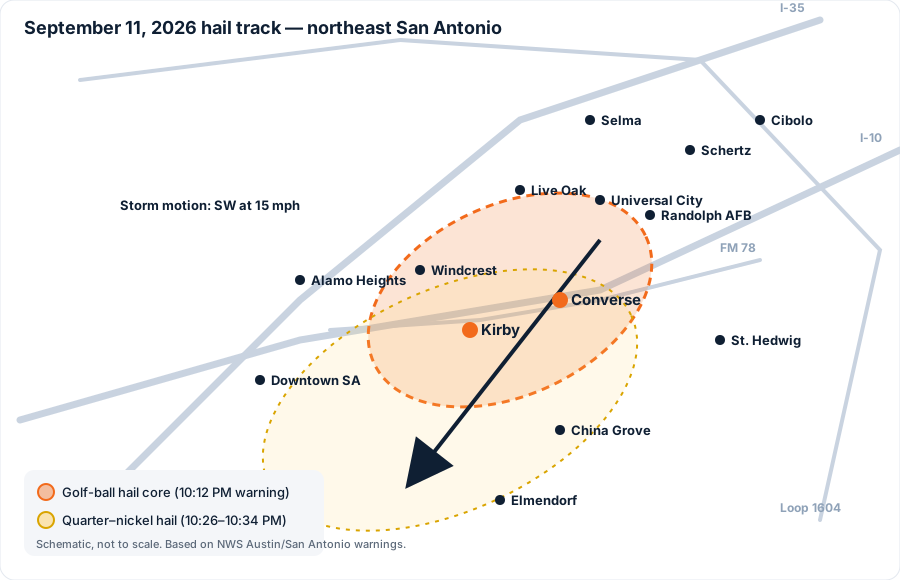
Late on Friday, September 11, 2026, a severe thunderstorm formed along a front and dropped into the northeast suburbs of San Antonio. The National Weather Service office in Austin/San Antonio issued a Severe Thunderstorm Warning at 10:12 PM CDT for a storm located over Kirby, near Converse, moving southwest at 15 mph, with golf-ball size hail and 60 mph wind gusts. Follow-up warnings at 10:26 PM and 10:34 PM tracked the storm toward China Grove and the south side, with hail sizes stepping down to quarter and then nickel size as it moved away from our area.
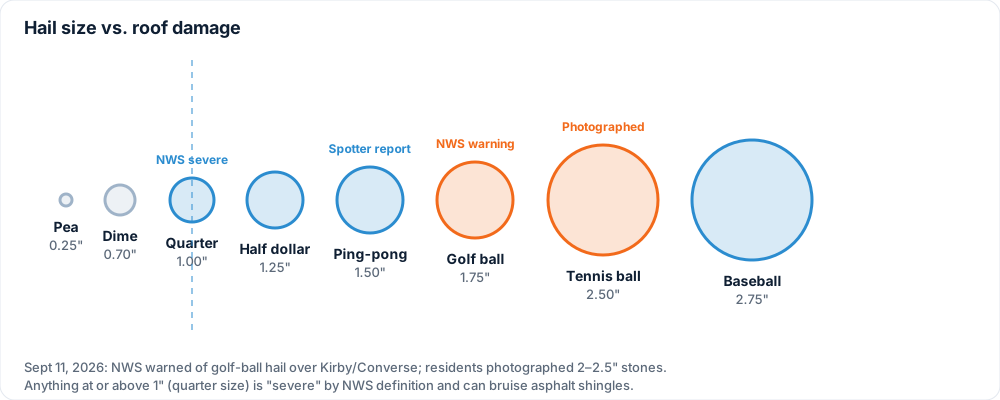
Trained spotters reported hail up to 1.5 inches between Converse and Kirby. Photos shared by residents on social media and KSAT Connect showed stones in the 2 to 2.5-inch range in Converse neighborhoods, alongside cracked windshields and broken car windows. Dime to golf-ball hail was reported in the Paloma subdivision. Pockets of the storm produced more than 2 inches of rain, with frequent cloud-to-ground lightning and localized street flooding.
CPS Energy reported more than 8,000 customers without power that night, most of them on the east side. About 4,600 of those outages were concentrated around Kirby and Converse.


Areas in the warning polygon
The NWS warnings listed these communities as impacted:
The heaviest, largest hail was in the first warning box, centered on Kirby and Converse. If you live between Loop 1604, I-10 and FM 78, your roof was almost certainly under the core of the storm.
Timeline
| Time (CDT) | Event |
|---|---|
| ~10:05 PM | Special Weather Statement issued ahead of the storm |
| 10:12 PM | Severe Thunderstorm Warning: storm over Kirby near Converse, golf-ball hail, 60 mph gusts, moving SW 15 mph |
| 10:26 PM | Warning update: storm near China Grove, 7 mi NE of Stinson Municipal Airport; quarter-size hail, 60 mph gusts; valid until 11:15 PM |
| 10:34 PM | Warning update: nickel-size hail, 60 mph gusts, continuing southwest |
| Overnight | CPS Energy outages peak above 8,000; crews restore power through Saturday |
| Sat 9/12 | KSAT publishes viewer hail photos and video; roofers begin canvassing Converse and Kirby |
What golf-ball hail means for your roof
The NWS "severe" threshold is 1-inch hail. Converse got 1.75 inches and larger, driven by 60 mph wind. That combination:
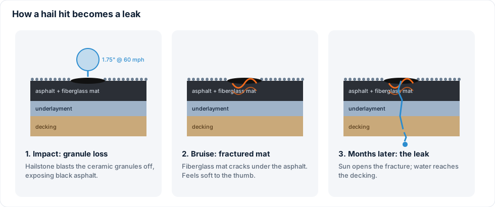
- Bruises and fractures the mat on standard 3-tab and most architectural asphalt shingles.
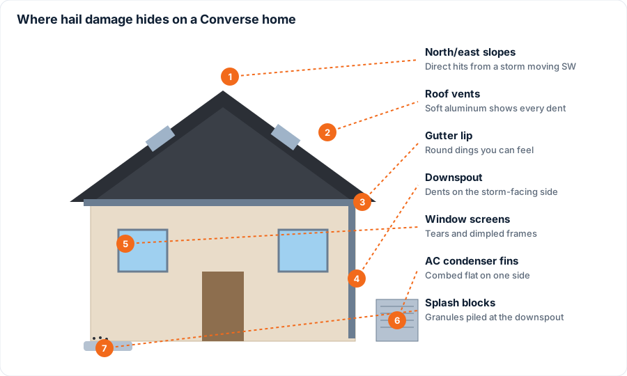
- Dents aluminum vents, gutters, downspouts and AC fins, which adjusters use to confirm the storm.
- Tears window screens and chips paint on north- and east-facing surfaces.
- Cracks skylights and damages solar panel frames.
Because the storm moved southwest, north- and east-facing roof slopes generally took the direct hits. A roof can be badly damaged on one or two slopes and look untouched from the street.

What to do this week
- Photograph what you can see from the ground: dented gutters, torn screens, chipped paint, granules at downspouts, car damage. Timestamps matter.
- Get a free roof inspection from a local roofer before you call your insurer. You'll know what the roof actually needs, and you'll have a dated photo report and written estimate.
- If there's damage, decide how you'll pay for it. If you contact your insurance company, the date of loss is September 11, 2026. Here's a homeowner's guide to the process.
- Be careful who you sign with. Out-of-town crews are already door-knocking. Seven questions to ask first.
- Never let anyone "cover" your deductible. It's illegal in Texas and can void your claim.
Sources
- NWS Austin/San Antonio Severe Thunderstorm Warnings, September 11, 2026, 10:12 PM, 10:26 PM and 10:34 PM CDT
- KENS 5: Power outages in San Antonio area amid Friday night storms
- KSAT: Viewers share photos, videos of hailstones and rain across San Antonio
- Stormersite hail reports, Converse, TX
Storm photos on this page are representative images. Add your own photos from Converse neighborhoods to the gallery as they come in.